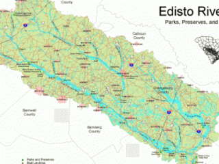
Edisto Basin Assessment Maps

The Edisto River Basin Project

The Edisto River Basin Project was designed to involve local citizens in the evaluation and planning of the regions ecological, cultural, and economic assets. A task force was organized to evaluate how these resources should be utilized and/or protected by making land use planning recommendations. A multi-resource data base was created during this project to assist in more efficient and proactive decision making. A geographic information system (GIS) was used to store and analyze this data base. The identification of potential conflict areas between resources was determined using this GIS.  The project was conducted by the Water Resources Division of the South Carolina Department of Natural Resources (SCDNR) in partnership with the South Carolina Department of Commerce and the South Carolina Department of Parks, Recreation, and Tourism. Funding was provided by the National Oceanic and Atmospheric Administration.  Fifteen committees were organized to assess the ecological, economic, and cultural resources of the Edisto River Basin. These committees developed recommendations as to how each resource should be utilized, managed, and protected. The resource assessment maps along with the recommendations were then presented to the Edisto River Basin Project task force and Basin residents.

Digital Atlas Instructions

This atlas was compiled using the Adobe Acrobat Portable Document Format (PDF). Adobe Acrobat PDF readers are available on most major computing platforms, free of charge.

Resource Assessment Maps


Ecological Resources

Economic Resources

Cultural & Recreational Resources

 
Natural Areas & Sensitive Species
 
Residential Development
 
Prehistoric Site Probabilities and Historic
  • Lower Edisto River Basin
 
Wildlife Habitat
 
Commercial Development
 
Recreational Boating
 
Fisheries Habitat
 
Industrial Development
 
Recreational Fishing
 
Wetlands
 
Agriculture
 
Recreational Fishing
 
Water Resources
 
Forestry
 
Recreational Hunting
 
Hydrologic Units
 
Tourism